 SKC Films Library |
| SKC Films Library >> Science >> Geology >> Dynamic and Structural Geology |
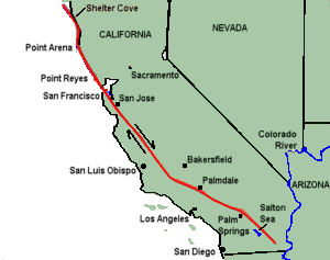
| San Andreas Fault a fracture in the earth's crust marked by a zone of disrupted land that extends more than 750 miles from off the coast of northwestern California to the southeastern part of the state near the Mexican border map of the San Andreas Fault What Is It? The Earth's crust is fractured into a series of "plates" that have been moving very slowly over the Earth's surface for millions of years. The San Andreas Fault is the main "boundary" between the Pacific Plate (to the west of the fault) and the North American Plate (to the east). Many smaller faults branch from and join the San Andreas Fault. The entire San Andreas fault system is more than 800 miles long and extends to depths of 10 miles or more within the Earth. Can You See It? Over much of its length, a linear trough reveals the presence of the San Andreas Fault. From the air, the linear arrangement of lakes, bays, and valleys in this trough is easy to spot. On the ground, the fault is marked by distinctive landforms that include long straight escarpments and narrow ridges. a 20-mile segment of the fault
through the Carrizo Plains How Does It Move? Blocks on opposite sides of the fault move horizontally. This means that if you stood on one side of the fault and looked across it the block on the opposite side would appear to be moving to your right (assuming you could actually see the movement), regardless of which side you are standing on. Geologists refer to this type of fault movement as right-lateral strike-slip. Movement along the entire fault averages 2 to 2¼ inches yearly. The movement of the plates along the San Andreas Fault produces strain on the rocks near the plate boundary. Along some segments of the fault the strain is released by frequent small earthquakes that do little damage. But along certain other segements the plates are "locked" in place, and the strain builds up over many years. The built-up strain occassionally produces a major earthquake. In 1857, a sudden movement along the San Andreas Fault in the Transverse Ranges caused a severe earthquake in southern California. In 1906, movement along another fault segment resulted in a major earthquake in San Francisco. During this latter earthquake, roads, fences, and rows of trees and bushes that crossed the fault were offset several yards, and the road across the head of Tomales Bay was offset almost 21 feet. During the past 15 to 20 million years, coastal California, along with the rest of the Pacific Plate, has moved about 190 miles in a northwesterly direction with respect to North America. In other words, way back in geological history, San Francisco would have been about half the distance to Los Angeles than it is now, and Los Angeles would have been south of San Diego.
WEB SOURCE |
| SKC Films Library
>> Science >> Geology >> Dynamic and Structural Geology This page was last updated on 12/04/2017. |
