 SKC Films Library SKC Films Library |
| SKC Films Library >> Science >> Geology >> Dynamic and Structural Geology |
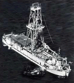
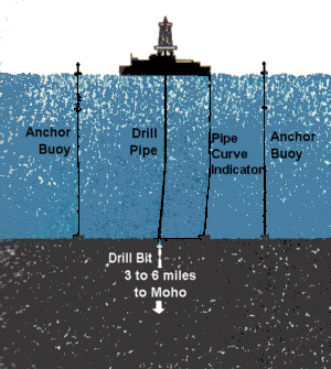
| The Mohole Project In 1959, at the International Oceanographic Congress in New York, American scientists announced a project to drill a hole four or five inches in diameter down to the boundary between the earth's crust and mantle. This boundary is called the Mohorovicic Discontinuity, or Moho, after its discoverer, Andrija Mohorovicic. The plan was to drill to the Moho Layer through the seafloor, where the earth's crust is thinnest. Drilling from an oceanic site would mean going through some 32,000 feet, of which the upper 14,000 feet would be water. Using a continental site would have meant drilling through about 100,000 feet of rock, while an oceanic island would require drilling about 50,000 feet. At the time, the deepest oil well only went down about 25,000 feet. diagram showing the Moho Layer History of the Moho Seismic waves resulting from earthquakes increase in speed when the density and rigidity of the rock through which they travel increases. It was by observing the differing echoes of the same seismic wave that Professor Mohorovicic first developed his theory in 1909 of the boundary between crust and mantle. Subsequent observations showed jumps in speed from four to more than five miles per second at average depths of four miles, beneath the oceans, and about 20 to 25 miles beneath the continents. These observations proved the existence of a definite boundary zone between the earth's crust and the denser rock of the mantle. Hoped-For Results Boring to the Moho Layer and obtaining actual samples of rock from the crust and mantle would, it was believed, provide a concrete check on theories about the age, origin, and composition of the earth. Analyses could be made of the rock samples for physical and chemical properties, electrical and thermal conductivity. The samples could be dated by means of radioactive isotopes. This would add to evidence already available from the study of meteorites and lavas, the earth's magnetic and gravitational fields, and from other data gathered by phyicists, earth scientists, and astronomers. If cores of undisturbed sediment could be obtained, they would provide information on ancient climates and on the evolution of life, as well as on past shifts of the magnetic poles. AMSOC and the Mohole The Mohole Project was first proposed by Walter Munk, a member of the National Academy of Sciences (NAS) and of the National Science Foundation (NSF) Earth Science Panel, in March, 1957. Munk proposed the idea to the American Miscellaneous Society (AMSOC), an informal group of scientists who regularly met to discuss boldly imaginative new ideas and projects. AMSOC, as well as the NSF and NAS, endorsed the idea. In 1958, after funds for the project had been obtained from NSF, AMSOC took charge of the effort, as an official study unit of the National Research Council's Division of Earth Sciences. The "Equipment" The Cuss I was an offshore drilling rig that had been specially adapted for the project. The vessel had previously drilled holes as deep as 5,000 feet in over 300 feet of water, but open ocean drilling presented many technical problems, including that of keeping the rig sufficiently centered over the hole. The navigation system employed submerged buoys with sonic equipment tuned to that of the rig, so that the exact position of the ship could always be ascertained. Four 200-horsepower engines helped to keep the ship in its desired location. the Cuss I diagram of how the Cuss I was kept
in place The First Drillings In March and April of 1961, the Cuss I drilled five holes off the west coast of Mexico, near Guadalupe Island, with the deepest reaching 601 feet into the sea floor, under 11,700 feet of water. The first cores showed that the first layer of crust extended 557 feet and consisted of sediment dating to the Miocene Epoch; the second layer was found to consist primarily of basalt. The Project Ends After the first drillings were completed, it was decided to shift operational control to the NSF, while an AMSOC committee continued to act as project adviser. This relationship soon proved unsatisfactory, however. Subsequent negotiations led the AMSOC committee to dissolve itself in 1964. After that, two National Academies committees advised the NSF Mohole activity until late 1966, when Congress discontinued the project due to increasing costs. Although the Mohole Project never succeeded in reaching the Moho Layer, it did prove that deep-sea drilling was possible. PRINT SOURCE WEB SOURCE |
| SKC Films Library
>> Science >> Geology >> Dynamic and Structural Geology This page was last updated on 06/09/2017. |

