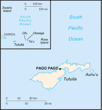
| Territory of American Samoa 
Total Area 77 sq mi
(199 sq km)
Highest Point Lata Mountain; 3,163 ft
(964 m)
Lowest Point Pacific Ocean, 0 ft (0 m)
Natural Resources pumice, pumicite
Nationality American
Samoan
Population (July 2016 est) 54,194
Ethnic Groups Samoan, Asian, mixed,
white
Religions Christian Congregationalist,
Roman Catholic, Protestant
Languages Samoan, English, Tongan
Capital Pago Pago
Form of Government unincorporated and
unorganized territory of the United States
Current Constitution Adopted June 2,
1966
Chief of State U.S. President Donald
Trump (since January 20, 2017)
Head of Government Governor Lolo
Matalasi Moliga (since January 3, 2013)
Legislature bicameral Legislative
Assembly (Fono)
Judiciary High Court
Currency U.S. Dollar
Per Capita Income $8,000
Industries tuna canneries, handicrafts
Agricultural Products bananas, coconuts,
vegetables, taro, breadfruit, yams, copra, pineapples,
papayas; dairy products, livestock
Export Commodities canned tuna
Import Commodities materials for
canneries, food, petroleum products, machinery and parts
National Holiday Flag
Day; April 17 (1900)
Flag blue, with a white triangle edged
in red that is based on the fly side and extends to the
hoist side; a brown and white American bald eagle flying
toward the hoist side is carrying two traditional Samoan
symbols of authority, a war club known as a
"Fa'alaufa'i" and a coconut fiber fly whisk
known as a "Fue"

Questions or comments about this
page?
|
 SKC Films Library
