 SKC Films Library |
| SKC Films Library >> Malaysia |
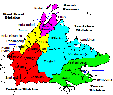
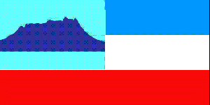
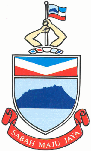
| State of Sabah Located on the northern part of the island of Borneo, Sabah shares its western border with the State of Sarawak and its southern border with the Indonesian Province of East Kalimantan. It is known locally as "Sabah, negeri di bawah bayu," which means "Sabah, the land below the winds," because of its location just south of the typhoon-prone region around the Philippines. location of Sabah Geography Sabah covers 26,400 square miles (73,711 square kilometers), making it the second largest of the Malaysian states. All three of the highest mountains in Malaysia are located in the western region of Sabah, with the central and eastern ranges consisting primarily of lower mountain ranges and plains. The most important river is the Kinabatangan, which winds its way from the western ranges through the central region and into the Sulu Sea. Sabah is also home to one of the world's largest rainforests. Population Sabah is the second most populous state in Malaysia (behind Sarawak), with an estimated population of 3,387,880 (2007). About two-thirds of the people belong to indigenous tribes, the largest of which are the Kadazans, Muruts, Bajaus, Kedayans, Sulu, Bisaya, Rumanau, Minokok, and Rungus. The largest non-indigenous group is Chinese, and there are also minor populations of Malays and Europeans. The largest city in Sabah is Kota Kinabalu, which also serves as the state capital. Other major cities include Sandakan, Tawau, Lahad Datu, Keningau, Semporna, and Kudat. Government The chief government official in Sabah is the Yang di-Pertua Negeri, which is roughly equivalent to a Governor in the United States. He is assisted in his duties by a State Cabinet. Lawmaking authority lies with the State Legislative Assembly. The Yang di-Pertua Negeri and members of the Assembly are elected by popular vote every five years. The state is divided into five administrative divisions, which are in turn divided into 24 districts. administrative map of Sabah Sabah is also divided into 25 parliamentary constituencies and 60 state assembly districts, each of which elects one member to Parliament and one to the State Assembly, respectively. Official Symbols The flag of Sabah is rectangular, in the proportion 1:2. The canton is icicle blue in color (symbolizing unity and prosperity), with a silhouette of Mount Kinabalu in royal blue (strength and cooperation). The fly is equally divided into three bands of colors, the foot of which extends to the hoist. The top band is zircon blue (peace and tranquility), followed by white (purity and justice) and chili red (courage and conviction). The design of the state flag was officially established on September 16, 1988. flag of Sabah The Sabah crest consists of two arms in yellow holding up the state flag resting on a band of all five state colors (as seen in the state flag). The two arms symbolize unity and cooperation among the state's multi-racial communities for progress and success of the country; the five colors represent the five divisions in the state. Immediately below the crest is the state shield, with a top segment consisting of the colors zircon blue, white and chili red in V bands. The lower segment of the shield contains the silhouette shape of Mount Kinabalu against a plain icicle blue background. The shield rests on a red scroll carrying the state motto "Sabah Maju Jaya" in blue. Sabah coat of arms Economy Timber continues to be the principal industry in Sabah, although timber reserves are gradually running out. Tourism is currently the second largest part of the state economy, with most tourists coming to enjoy the state's many national parks, diverse flora and fauna, and/or the divers' paradise available off the coast and around the off-shore islands. Palm oil is the principal agricultural product, followed by rubber and cacao. Sabah is served by one international airport, at Kota Kinabalu. History In the 16th century what is now Sabah was part of the Sultanate of Brunei. In 1658, the Sultanate of Brunei fought with the island of Singhs, and then ceded the northeast portion of Borneo to the Sultan of Sulu to compensate the latter for his help in settling a civil war in Brunei. In 1761, the British East India Company made an agreement with the Sultan of Sulu allowing the company to establish a trading post in the region. The post, along with an attempt to build a settlement and military station centered around Pulau Balambangan, failed, however, and international interest in the area all but disappeared. In 1865, the American Consul of Brunei obtained a 10-year lease over North Borneo from the Sultan of Brunei. Ownership of the lease was then transferred to an American trading company, which attempted to establish a trading base and settlement at Kimanis. When those attempts failed, the rights were sold to the Austrian Consul in Hong Kong, who later obtained a new 10-year lease. In 1881, the trading rights were transferred to the British North Borneo Provisional Association Ltd. The British North Borneo Company was formed the following year, and established Kudat as its capital. The capital was moved to Sandakan in 1883 to better capitalize on the region's vast timber resources. The British North Borneo Company retained administrative control over the area until 1942, even after it became a British Protectorate in 1888. The Japanese invaded Borneo in 1942, and occupied most of the island until 1945. After World War II the island became a British Crown Colony, with Jesselton (now Kota Kinabalu) as its capital. Sabah remained a Crown Colony until 1963, when it joined the Federation of Malaysia. SEE ALSO |
| SKC Films Library >> Malaysia This page was last updated on 07/15/2018. |


