| Republic of The Gambia Location western Africa
Bordered By Senegal
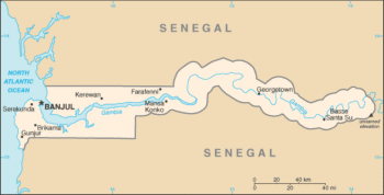
Area 4,361 sq mi
(11,295 sq km)
Greatest Distance N-S 30 mi (48 km)
Greatest Distance E-W 180 mi (290 km)
Highest Point unnamed; 174 ft (53 m)
Lowest Point sea level
Natural Resources clay, silica
sand, titanium, tin, zircon
Nationality Gambian
Population (July 2015 est) 1,967,709
Largest Cities Brikama, Bakau, Banjul,
Farafenni
Major Ethnic Groups Mandinka, Fula,
Wolof, Jola, Serahuli
Principal Languages English (official),
Mandinka, Fula, Wolof
Major Religions Musli,. Christian
Capital Banjul
Form of Government republic
Current Constitution Adopted August 8,
1996
Chief of State and Head of Government President
Adama Barrow (since January 19, 2017)
Cabinet appointed by the President
Legislature unicameral National Assembly
Judiciary Supreme Court of The Gambia
Local Administration 5 divisions, 1 city
Currency Dalasis (GMD)
Per Capita Income $1,600
Industries peanuts, fish, hides, tourism,
beverages, agricultural machinery assembly, woodworking,
metalworking, clothing
Agricultural Products rice, millet, sorghum,
peanuts, corn, sesame, cassava, palm kernels; cattle,
sheep goats
Export Commodities peanut products, fish, cotton
lint, palm kernels
Import Commodities foodstuffs, manufactures,
fuel, machinery, transport equipment
Independence Achieved February 18,
1965
From United Kingdom
National Holiday Independence Day; February 18
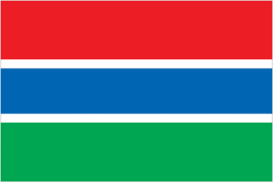
Flag red stands for the sun and the savannah,
blue represents the Gambia River, and green symbolizes
forests and agriculture; the white stripes denote unity
and peace
SEE ALSO
Senegal
Questions or comments about this
page?
|
