| Virgin Islands of the United States Location about 40 miles east of
Puerto
Rico

Largest Islands St.
Croix (82 sq mi), St. Thomas (27 sq mi), St. John (19 sq
mi)
Total Area 133 sq mi
Coastline 117 mi
Highest Point Crown Mountain (St.
Thomas); 1,556 ft
Lowest Point Caribbean Sea; sea level
Natural Resources none
Population (July 2015 est)
103,574
Largest Cities Charlotte Amalie,
Christiansted, Frederiksted
Ethnic Groups black, white, Asian
Languages English, Spanish Creole,
French Creole
Religions Baptist, Roman Catholic,
Episcopalian
Capital Charlotte
Amalie
Form of Government organized,
unincorporated territory of the United States under the
jurisdiction of the Department of the Interior
Chief of State President Donald Trump
(since January 20, 2017)
Head of Government Governor Kenneth
Mapp (since January 5, 2015)
Currency U.S. Dollar
Per Capita Income $14,500
Principal Industries tourism, petroleum
refining, rum distilling, textiles, electronics,
pharmaceuticals, watch assembly
Agricultural Products vegetables; beef cattle,
chickens, eggs, goats, hogs, milk
Export Commodities rum, refined
petroleum products
Import Commodities crude oil,
foodstuffs, consumer goods, building materials
First Explored By Christopher
Columbus in 1493
First European Settlement on St. Croix, by Dutch
and English settlers in 1625
Purchased from Denmark January 17, 1917
Territorial Status Achieved 1927
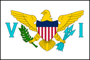
Flag a white field
bearing a golden American eagle with the shield of the
United States on its breast; the eagle holds a sprig of
green laurel in its right talon, and a bundle of blue
arrows in its left talon

SEE ALSO
Puerto
Rico
Christopher Columbus
Questions or comments about this
page?
|
 SKC Films Library
